Colrain, Massachusetts 01340
Colrain, MA Business Lodging Real Estate History
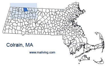
The community of Colrain rests on the Vermont border and is 45 miles north of Springfield, Massachusetts, and borders Vermont to the north. In 2006, the Colrain city center was declared a state historic district, because it has been well preserved for the last 150 years.
Colrain, Massachusetts is made up of many different villages: Elm Grove, Lyonsville, Foundry Village, Shattuckville, Griswoldville, Colrain City, Catamount Hill, Stewartville, and Gimletville. The areas of Colrain not included in these villages are mostly woodlands.
Share Colrain, Mass. information or feature your business, contact us.
Settled: 1735
Incorporated: 1761
County: Franklin
Colrain, MA Population:
2008: 1,879
2000: 1,813
1990: 1,757
inns | hotels | resorts | rentals | attractions | dining | real estate
SUGGESTED MA BERKSHIRES LODGING Visit Western MA Vacation Specials. Browse current Amherst MA area vacation rentals, inns, resorts, and pet-friendly lodging availabilities below.COLRAIN MA GIFTS
MASSACHUSETTS TOWN GUIDES
Inns | Hotels | Resorts | MA Vacation Rentals
Real Estate | Products
Dining | Attractions | Business
History | Weather | Beaches
Fishing | Golfing | Towns
Art Galleries | Massachusetts Shopping
Free World Mall
Country Weddings | New England Recipes
Red Sox Gifts | Paradise Coast Living | New England Living


